Tuesday, March 6, 2012

Art on the Divide Gallery

Today I was welcomed into the fold of the Art on the Divide Cooperative Gallery. I'm proud to have been included among this fine group of artists who produce exceptional work. I'm looking forward to getting to know and learning from them. The gallery is located in a historic building in Georgetown, California. Fortuitously off the beaten track, Georgetown has escaped the "quaintifying" transmogrification that has blighted so many of the old gold rush communities. C'mon up and see us sometime.

Here is a sampling of the work that I will be showing there beginning March 30:

Loon Lake

Bud's LaSalle

Codfish Creek

Backyard Maple

Snowy Egret, Cool, CA

Winter Oak, Knickerbocker Flats, Cool, CA

The Red Caboose, Portola, California

Bufflehead Pair, Newport Bay preserve, CA

Morning Paddle, Eagle Lake, Lassen County, CA

Friday, February 24, 2012

Hike No, 8 - Olmstead Loop South

February 24, 2012
5.5 miles


It was much too beautiful a day not to play hooky. So after dropping Tanner, our 10-year-old Shi-Tzu off at the vet in Cool for teeth cleaning and to have a few cysts removed, I drove south on 49 to Auburn State Recreation Area (ASRA) State Park Gare No.128, which is perhaps 1/4 mile on the right after you pass Northside School. There is room for perhaps four cars there, but no problem at 9AM on a Friday. I hung my Golden Poppy Pass on the visor, and headed off with my Panasonic GH2 and two lenses: a 14-45mm and a 45-200mm. On this camera the focal length factor is 2, so in terms of a full frame, or 35mm camera, they provide a focal length range of 28mm to 400mm. The whole kit weighs only ___ ounces. The camera with even the long lens is a barely noticeable weight around my neck.


From the Journal


The trail winds through an ecoregion I have seen referred to as rolling oak woodland, which to me is descriptive of the low, rounded grassy hills dotted with copses of oaks. But Wikipedia refers to the foothill grasslands and oaks as blue oak woodland, consisting of Blue Oak, interior Live Oak, Valley Oak, Canyon Live Oak and California Scrub Oak. I've not yet learned to identify the various oaks, but I did also see pines on the slopes of Knickerbocker Creek Canyon, possibly Ponderosa, and some large Manzanita, one in full bloom.


Ruby-throated Hummingbird. Taken with the 200mm (400mm as 35mm equivalent). And cropped quite a bit. The 16 megabyte images tthe GH2 produces are clean enough to survive considerable enlargement.
Cattails near one of the creek crossings. It has been a very dry year so far, so I was able to keep my feet pretty dry.

Rolling oak Woodlands. These beautiful, open grasslands and groves will be a brilliant green for a while in April and May.

I just can't resist rustic fence posts

Oaks in winter mode

Horses are thankful for this spot in the summer. Even in February, I could have used a second bottle of water.

Manzanita

It was a treat to come upon the pond, which I hadn't seen before. 

There were a few Coots and a pair of Mallards. But they hid in the rushes and over-taxed my photographic patience this day.

My "secret" pond. There is a fine grassy meadow sloping down to the water here - perfect for an afternoon of reading, napping, and photographing birds. I flushed a covey of quail near here, with a thunder of wings. I also encountered a couple groups of Flickers, and saw A red-Tailed Hawk, and the ever-present Turkey Vultures soaring in the distance.


A fine day to be out

My Ruby-Throated Hummingbird again


Tuesday, February 21, 2012

Hike No. 7 - Knickerbocker Narcissus

February 15, 2012
2.5 miles


In which I go in search of the annual bloom of the Wild Narcissus garden at the abandoned Knickerbocker Ranch and try out my new Panasonic GH2

A nice 2.5-mile ramble among the trees, creeks, and ponds of the rolling oak woodlands of the Auburn State Recreation Area
The commercial hub of our little town of Cool, about 6 miles south of Auburn, and 40 some miles east of Sacramento, backs up to the Auburn State Recreation Area, or ASRA. From my chair in our dentist's office I can look out across meadows to rolling hills doted with copses of oaks. A graveled parking, or staging area, located behind our firehouse, provides access to the trails in our portion of the park. When I rolled in on a Wednesday afternoon and hung my Golden Poppy pass on the rear view mirror there was one truck and horse trailer and one other car in the parking lot. On weekends there are normally a couple of dozen vehicles here, and many more during the many equestrian, cycling, and running events held on the trails. Since this access point is less than five minutes from our house, I get a lot of use out of that pass here. Today was exciting as it was my first outing with a new camera. After much interesting reading of reviews and perusing of specification, the micro-four-thirds Panasonic GH2.

I pause under an oak to let a pair of equestrians by
 From the staging area I headed down the broad and well-paved road once used as a haul road to the dam site on the south side of the river. But I quickly left it for the parallel trail that criss-crosses a small creek, and photographed a couple of equestrian groups.
A multi-use trail - bikes, boots, horses, and dogs.

This pair of riders kindly paused for a photo with their dogs.

Stepping stones and rustic bridges provide crossings as the trail meanders back and forth over this little creek.

Leaving the creek, crossing the road, and heading up the side of a ridge along an old fence line, I played a bit with one of my favorite subjects - weathered wood. Here I framed a distant oak between a pair of fence posts since I kind of liked the whimsical composition, and wanted to test out the Panasonic 14-42mm lens at f22.

Black and white conversion in Light Room 3

The pond on Salt Creek

I can't resist weathered stuff.

The bedrock mortars next to Salt Creek Pond

Approaching the old Knickerbocker Ranch site

Knickerbocker narcissus with the pond in the distance

Narcissus at the Knickerbocker Ranch

At the Knickerbocker Ranch
Although no quite so exuberant this year because of the dry weather, the narcissus are still a nice surprise at the old ranch site. Below, a bit of the Olmstead Loop trail as i head back toward the firehouse parrking area.
On the Olmstead Loop Trail near the firehouse at Cool

Friday, February 10, 2012

Hike No. 6 - A Walk with Tanner

February 6, 2012
1.2 Miles

OK, calling a 1.2 mile dog walk a hike may be stretching it, but we both enjoyed the outing, and returned relaxed and refreshed. That's what it's all about.

It was a gray day, portending the rain that came a few hours later. I had a goal in mind, which was to bring home an image I could play with in my new software toy, Nik Color Efex 4. This software consists of a long list of filters, which can make strong changes to images. You can use them to enhance an image within whatever you consider "traditional" photography, or you can go all out, and create images only seen in your mind's eye.

As you can see, with this one I went all out. What I like about the program is that it loosens up my vision, getting me out of the Ansel Adams and David Muench modes that I hold so dear.

What the camera saw ...

... and what the mind's eye saw - with a little help from Nik.

Hike no. 5 - Codfish Falls


February 3, 2012
3.2 Miles


I accessed the trailhead, located where the Ponderosa Way Bridge crosses the North Fork of the American River, by dropping down Ponderosa way from the Foresthill Road between Auburn and Foresthill. You can also zig-zag down Ponderosa way from I-80 near Colfax. Either way you are dealing with switchbacks, dirt roads that are rough in places, and some fine views of the canyon of the North Fork. You would probably make it fine in your Miata, but feel most secure in a high-centered, AWD vehicle.

The frosty Ponderosa way bridge over the North Fork off the American River
I crept carefully in our venerable Explorer across the frost-covered wooden planks of the bridge, still in the shade of the deep canyon at 10 AM. The rusty cable railings didn't look like they would help much if we began slipping sideways. The river ran clear and cold below, carving into bedrock strata of seafloor sediments tilted to nearly 90 degrees. A light jacket over my fleece vest felt good as I started down the trail, but as it emerged into sunlight I stopped to stuff it in my daypack. Also in the pack was my Sigma 10-28mm wideangle lens, and around my neck on a comfortable strap was my old Nikon D80, extracted from retirement today to see if its lighter weight compared to the D300 would make it a good hiking camera. Attached to it was my not-quite-do-everything Nikkor 18-200mm VR, with which I have a conflicted relationship. Conflicted, because the designers were unable to figure out how to keep the zoom from slipping to full extension as the camera dangles from the strap. Or when angled downward to frame a photo. A bit of duct tape goes into the pack next trip. In my hand I carried a tiny Velbon tripod. I lust for a carbon fiber, but but have not yet gathered the gumption to spend the required $600.*

The trail to Codfish Falls
Any lustful or negative thoughts regarding photo gear were totally buried by the delight of the trail, which makes its level way downstream on the sunny side of the canyon, always within sight and sound of the river. Casual slip-and-slide side trails make their way down to the river, where sandy beaches and swimming holes would be attractive in the summer.

The morning light spilling down the opposite slope of the canyon outlined the tall Grey Pines in delightful backlighting. Until recently these trees had been know commonly as "Digger Pines", a name applied with reference to the Nissenan, or Southern Maidu, by the gold miners of the 1800's, based on their observation that they commonly dug up roots for food and other uses. The miners also left behind piles of cobbles on a bar along the opposite bank, washed clean by hydraulic mining. The resulting sediment carried down the American, and other rivers, into the Central Valley built up there, causing flooding and damaging agricultural land. A temporary solution on the NF was to build the Clementine Dam downstream a few miles, solely for the purpose of trapping the sediment before it could be carried further downstream. Shortly thereafter the release of sediment was outlawed by the nation's first environmental legislation.
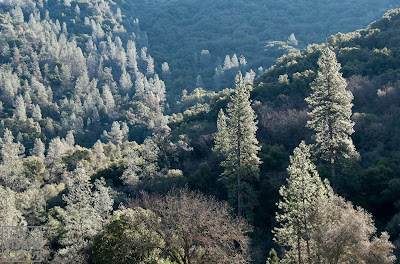
Grey pines backlit by the morning sun
What with several photo stops it took me about 45 minutes to walk about a mile to the point where the canyon could be seen through the trees to open up into a side canyon, cut by Codfish Creek. About here, as the trail began to turn into the side canyon, a shallow, overgrown canal could be seen paralleling the trail. It was likely used by gold seekers to carry water from Codfish Creek for the hydraulic mining.

Codfish Falls

Hike No. 4 - Clark's Hole


January 30, 2012
1.2 Miles
The kiosk map at the trail head gives a vague idea of the many interesting trails at the Confluence, where the North and Middle Forks of the American River join

Clark's Hole is also referred to more genteelly as Clark's Pool, as does the weakly informative kiosk map above. I prefer the former, coming from the early 1900's, a time less steeped in irony. According to American River Canyon Hikes, it was then a municipal swimming hole used by the City of Auburn, complete with a lifeguard and concession stands. I had failed to find it on a couple of previous outings, but figured finding it was worth another effort as a potential summer outing destination with grandchildren. Previous experience has revealed the water temperature of the North Fork at the Confluence to be noticeably warmer than the Middle Fork, since it is made up of the sun-warmed surface water from Lake Clementine that spills over the dam a few miles upstream.

I used my Canon G12 on this outing.

The subtle Clark's Hole Trail were it splits off from the road behind gate No. 137
The trail begins at the Auburn State Recreation Area gate No. 137 near the ASRA kiosk, small parking area, and restrooms. A climb up this wide trail soon comes to the intersection with Stagecoach Trail on the left. About 40 paces beyond on the right the Clark's Hole trail, barely more than a deer path at this point, carves its way down the steep slope above the North Fork. I had discounted it previously as one of several casual trails that access the river.

A pleasant, shady trail
The narrow path is well-carved into the slope, and soon widens out into a very pleasant and apparently little-used path along an old road bed. Spots of sunlight felt good, and the late January air was cool and moist following a series of rain storms. Occasional small creeks cross the trail, and ferns are numerous beneath the oaks and firs. The trail became a bit vague at a couple of spots, where the road had washed out or trees had fallen. I got into a bit of trouble where the road was buried by rubble from building of the Foresthill bridge in the 1970's, but backtracked and soon picked up the trail through the moss- and lichen-covered boulders. I tried to not spend too much time here, leery of monkey wrenches tumbling from the construction work going on overhead.

Looking across the river at the east support of the Foresthill Bridge. The highest in California, the bridge is 730 feet above the river.

Anybody home? The rubble pile beneath the west tower of the Foresthill Bridge.

Moss and ferns near Clark's Hole

The trail arrives at Clark's hole through a patch of blackberries

Clark's hole turns out to be located just below the first big bend of the North Fork above the Confluence. Bedrock slabs about 8 feet above the river provide diving platforms into the still water, but there are no shallow water beaches where small children can safely play. This would be a great place for teenagers to display diving skills and lay out in the sun, but I prefer the swimming hole just below the old Foresthill bridge, with it's gently sloping gravel beaches leading to deeper water, the current to play in, and the diving rocks on the east bank.

These rainwater-filled depressions in the bedrock next to Clark's Hole are probably bedrock mortars once used by the Nisenan or Southern Maidu Indians. In places like this I like to pause a moment to still my mind and imagine the tok - tok - tok of the pestles, the gentle conversation of the women, the voices of playing children, and the background murmur of the river.


Photographs © 2012 Tony Mindling