Thursday, May 25, 2017

Central Nevada Road Trip - Part 5. Monitor Valley South and the Belmont Bar.

Note that you can click on a photo to view it full screen together with a slide show of all of the pics.

Our trusty truck negotiates some desert two-track and generates that wonderful sage aroma while exploring southern Monitor Valley. We were looking for a scenic area of eroded white volcanic ash  we assumed was on the west side of the valley. When I took this photo I didn't realize that the real White Rock was directly behind us, appearing as patches of snow right of center in this photo. But it's all about the journey, right?!


Journal for Thursday, 5/11/17 - Continued

In which we explore a couple of brick mills in Monitor Valley, fail to find White Rock, meet the folks at the Belmont Bar, and learn that it's all about the journey.

Following our photo tour around Belmont, and our meetup with Puggie who inflated our limp trailer spare tire, we went back to the camp site to install it. Well, Eric installed it while I built us a couple of San Juan tuna fish sandwiches for lunch, off we went in search of “White Rock”. The journey took us past the Combination and Monitor-Belmont mills, where I photographed them for the lovely color of the red brick with the huge blue valley spread out in the background. But I also worked some of the photos into black and white, showing the mills as lonely ghosts. As our search for White Rock took us further south down Monitor Valley we found increasingly sketchy roads, leading us onto some delightful two track and finally to a pair of tracks through crushed sagebrush, producing a distinctive Nevada ambiance. Despite my uncertainty of the trucks abilities, she took us through gulches and up gravelly slopes without hesitation.

The Monitor-Belmont Flotation Mill was built to re-work old
tailings during WWI
Eventually we explored on foot through a deposit of very light-colored volcanic ash within a forest of pinon and juniper trees and sagebrush. A distinctive wild horse pathway led past the area, marked with one truly impressively stacked accumulation of droppings, which were later told was “placed” by a lead horse marking its territory.


A natural bonsai juniper about two feet high and volcanic ash, southern Monitor Valley


The photographic opportunities within the eroded columns and ridges of the white ash were OK, but the real pleasure was mostly in the desert ambiance; the clear fragrant air, long views, and the counterpoints of tiny flowers extending on seemingly delicate stems above a soft cluster of leaves which when touched were found to be as tough and bristly as a hedgehog.

So we retraced our route, stopping again at the mills to take advantage of the late afternoon light. At the base of the tall stack of the Combination Mill I knelt to get a view looking up through the tall opening, I put my had down to brace myself, felt something soft, and gently placed the long-deceased mouse out of the way.

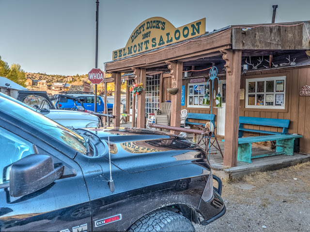
Dirty Dick's Belmont Saloon
Puggie had invited us to stop by the bar in the evening with our binder of photos, but neither of us being bar types we clomped up on the wooden porch and approached the door with some apprehension. How would a group of tractor hat rednecks react to us camera-toting tourists? We opened the door and entered, expecting to perhaps be barely tolerated or even simply shut out. A couple of hours later we left with the warm feeling of having met some new friends and having even perhaps contributed to their enjoyment of the evening.


Buddy's wolf-dog, Cassie, rests as he peruses the famous
black binder of 50-year-old Central Nevada photos
The first person we met was Buddy. Actually, Buddy’s wolf dog, Cassie, who at first put on a bit of a show of ferocity, then relaxed into her normal self, accepting an ear scratch then lying at Buddys feet while he paged through the black binder, which was rapidly gaining fame. Buddy is about my age, that is to say, really old. When he saw the photos of the mine structures in Tonopah he explained that he had worked as a contractor making many of the structural improvements to them as they were being stabilized to open to the public. He was especially proud of a tunnel he had developed that provides visitors with an underground view of the 1,000 foot deep open trench which was used to exploit the surface deposits and then just kept on going down. 

Henry offered to give us a tour of the courthouse, and then spent a couple of hours with us there a couple of days later. John had stories about the mines and also the ranches in the book, giving me some names of people and places that I scribbled in the margins with a Sharpie borrowed from Bertie, the bartender and Henry’s wife. I recall her as being a bit reserved the first night we met her, but by the time we returned the evening after our visit with Henry to the courthouse she was full of smiles and interest in how the tour had gone, and questions about, "had we seen so-and-so’s name on the wall", and "had we really gone all the way up into the cupola?!" And all because of that book, which I promised to reproduce and send to the bar with even more photos. I’ll be getting after that, just as soon as this obsession with getting down the words documenting our fine road trip peters out.

The glass cylinder pump, now a museum piece, that
welcomed Jean and I when we rolled into Belmont
with a near-empty gas tank in about 1970.
Before we left the bar I had to take photos of the old glass-cylinder gas pump which had been restored and was on display next to a wonderful old 1800’s painting of a woman lying on a downy bed in a state of considerable disarray. That pump had some meaning to me, as it had saved our butts about 50 years earlier when Jean and I had gone on a tour in our 1951 Plymouth sedan around Monitor Valley. That was back when I’d been “sitting wells”, meaning working long shifts collecting and describing samples as they were being drilled, and then even more interminable shifts doing hydraulic testing, in 1969 and 1970. But I had 48 hours off between shifts, so Jean would come down with Ian, then just about two years old, and I would show her around. This day, after visiting Belmont, Stonehouse and Diana’s Punchbowl, I decided for variety to loop back south on a road along the other side of the valley. All went well until we were within just a couple of miles of the main road when our road plunged through a steeply eroded gully that would have been a challenge for a 4X4 but not even to be considered with our Plymouth sedan. This meant that we had to retrace our route, arriving in Belmont at sundown without enough gas to get ourselves back to the Sundowner Motel in Tonopah. But glowing in the last light as we finally rolled into town was that glass cylinder atop the pump. I had to trot down the hill a bit to knock on the door of the service station’s owner, who came out and filled our tank. I can still recall the relief and pleasure at seeing that precious amber-colored fluid slosh up into the cylinder as the owner worked the hand pump.

The Cosmopolitan was still standing back in 1969 when Jean and I rolled into Belmont after a days exploration of
Monitor Valley. and with less than enough fuel remaining in the tank of our 1951 Plymouth to get us back to our motel in Tonopah. The glow of the last light in the glass cylinder atop the old gas pump lifted our hearts.


At some point Puggie arrived at the bar. Told where we had got to that day, she pulled up some photos on her cell phone of the “real white rock”, a fascinating looking area of volcanic ash that has been wind-eroded into fantastic arches and caves. Eric and I agreed that we had to attempt to find it again. “Just go straight across the valley from the Belmont-Monitor Mill,” she said, “You can’t miss it”.

.
Drinking up the delicious desert air and the near-infinite space of Monitor Valley. The snow-covered mountains behind Eric include 9,400 foot Kawich Peak, 45 miles to the south. Monitor Valley is about six miles across at this point.
.
Late afternoon sunlight sets last year's sagebrush flowers aglow at the Belmont-Monitor Mill
.
Our visit to the southern end of Monitor Valley was blessed with a Kodachrome sky.
This black and white was developed in Lightroom, darkening the blue slider and lightening the orange one, simulating the use of a deep red filter in film photography to provide a dramatic ghostly efffect.

The tall brick stack of the Combination Mill looms over the vastness of Monitor Valley.
.
Among the gullies and hoodoos of the volcanic ash formation in the southern part of Monitor Valley. Although we failed to reach the real "White Rock", we enjoyed poking around on two-track roads and taking in the desert ambiance.
.
Puggie and Bertie serve up at the Belmont bar, AKA "Dirty Dick's Belmont Saloon"


Eric, Buddy, and friends at the Belmont bar. Eric and Henry discuss some of the photos in the black binder

Dogs, friendly folks, and even kids at the weekly pot luck night give the Belmont bar the warm family-friendly ambiance of a British pub.

Eric and John peruse my old photos of the Tonopah-Belmont area taken back in 1968-1970 
.

Wednesday, May 24, 2017

Central Nevada Road Trip - Part 4. Belmont Town


Breakfast among the fragrance of pinon pines and junipers in the Belmont Campground


The journal - Thursday, May 11, 2017 - Belmont, Nevada

Despite a good night’s sleep after Eric’s fine dinner and a relaxing evening, both of us scribbling in our journals, I woke a bit anxious. What to do in a remote desert campground with a failing tire on the trailer. And how would it affect our limited time here? We must deal with the tire before anything else lest it be hanging over our heads. Would the truck jack lift the 4-ton trailer? And where the heck is the truck jack, anyhow? Oh, and will there be any air in the spare – the last time it was checked was when we bought a new set of tires for the trailer? Finally I told myself, “You are not alone”. That affirmation eased my troubled mind, and I was able to enjoy breakfast sitting next to Eric in a spot he’d picked where the sun just balanced the cool air, and we had a good view down the valley we’d driven up the evening before.

There are good reasons for why I am a bit of a hand-wringer. A bent toward deferred maintenance and less than complete preparation for contingencies are a couple. Loose lug nuts and bits of the hitch falling off had brought Hilda and I within a hairsbreadth of catastrophe in the past. Although I learned from each event, what’s going to happen next? The fact is, without Eric’s having agreed to join me on this adventure, my anxieties at the thought of leaving the security of home would likely have totally nixed the plan before I would have begun even deciding on photo gear to take.

Texture in the clear light of Belmont
So, sitting in the pleasant sunlight and influenced by Eric’s calmness, we made a plan to leave the trailer in the campground, hump the flaccid trailer spare into the back of the truck, and head into town and see if we could scare up a compressor. We rolled into a sweet little town that was dead quiet. No one outside, no curtains slipping back into place after curious peeks. There were several nice homes scattered around, but few vehicles. It was as if the town was on vacation. So we poked around with our cameras enjoying arranging texture and color through our viewfinders. As with the old mine buildings in Tonopah, those textures together with my long experience of dabbling black and white prints through trays of darkroom chemicals led me to envisioning many of the images in shades of gray. I was soon “in flow” – that delightful experience of being transported into one’s own timeless space of creativity. I’d brought along my binder filled with a dozen or so of silver gelatin (i.e., “black and white”) prints from the negatives I had made in Belmont and its Central Nevada environs back in 1968 and 1969, so for a while I was quiet lost in wandering the quiet town identifying the buildings, or lack of them, which I had photographed back then. Many were still standing, and in the case of the two-story courthouse with its cupola, actually in better shape than it had been nearly 50 years ago. Unfortunately, the lovely Cosmopolitan Hotel had crumbled into a heap of warped and weathered lumber some time ago. Already teetering, it finally disintegrated with the help of some yahoos with a cable, truck, and no brains.

At some point a barking dog broke into my consciousness when it roused itself to come from under a mobile home trying to play the role of a dependable protector, but blowing it with wagging tale and an eagerness to have its ears scratched. A woman emerged from the big shiny fifth wheel in a bathrobe, who admitted to having an air compressor when queried after a moment of polite explanation. Great. We said would come back with the tire after poking around town a bit. And giving her time to adjust herself for a further social encounter.

Diane, or “Puggie”, turned out to be a pleasant-looking and energetic woman in bright red T-shirt and jeans in the mid-thirties who has owned and operated the bar adjacent to her home for the last half dozen years or so. The bar, officially Dirty Dick’s Belmont Saloon, is the only enterprise in town with more or less regular hours. Inasmuch as we ended up visiting the bar for three nights in a row doing research, more will be written about it and its inhabitants – actually a whole section of this blog series – in the near future.

In front of the former and unfortunately demolished Cosmopolitan Hotel in Belmont.
My black binder of prints of the photos I took back in 1968 and 1969
provided a reminder of places I wanted to re-visit and better yet a connection
with the people of Belmont
While the black binder of old photographs was nice to have for comparing and reminding me of the places I’d photographed those decades ago, it actually got thrown in along the several maps and guidebooks in the expectation that it might serve as an icebreaker as we met people along the way, and that I might learn a bit more about the places photographed. It succeeded on both counts well beyond my imagining, beginning with Puggie, who after thumbing through it said we should bring it to the bar that evening, as there would likely be some old-timers who would like to see it.


So off we went, happy and pleased with our encounter with Belmont, and looking forward to a day of exploration of the two mills outside of town, and an area called “White Rock”, that Puggie recommended we see. “You can’t miss it,” she said.


The Philadelphia House, Belmont. Built as the superintendent's home and office of the Combination Silver Mining Company in 1866. During the following 20 years the Belmont mines yielded $15 million in mineral production. Subsequently the building was the home of Rose Walter, a local girl who married a miner named Jack. By 1950 Jack had died of silicosis and the mines had been long played out, but Rose remained for 30 years as protector of the town - "These old  houses, such as they are, still belong to someone somewhere".


The former Nye County Courthouse in May, 2017.


The Nye County Courthouse in 1968
The second floor windows open onto what was the district attorney's office. At one time a local mule skinner, a kindly simple man and the butt of jokes, got elected to the office. He enjoyed the perks so much, including a comfortable chair and huge oak desk, that he wouldn't leave when his term was up. Here's a tune about that event, "The Ballad of Andy Johnson":


Henry was one of the Belmont residents who paged with interest through the black binder of 50-year-old photos. Closing the binder, he graciously offered to provide us a tour of the old courthouse building. Henry and others have worked with Nye County, Nevada State Parks, and a group of donors and volunteers, Friends of the Belmont Courthouse, to secure the building with a new roof, windows, and doors. Massive interior structural improvements were made to stabilize the building, although Henry bemoaned the loss of portions of the graffiti covered lath and plaster , necessary to install the new structural members - "Lots of history lost there", he mourned for the missing signatures, some as old as the 1910's. 
.
Henry describing the purpose of one of the artifacts he's collected in glass cases in the old courthouse. He had stories for old pipes and horseshoes, the rooms in the building, and the names in the graffiti on the walls.
Henry's dog rests in the former courtroom on the second floor of the courthouse.

Addendum - 

How to get there and services

Belmont is about 47 miles northeast of Tonopah. Follow Hwy 6 east from Tonopah for about 5 miles and turn north on Hwy 376, a paved road. After about 13 miles turn right onto Hwy 82 and follow it for about 27 miles into Belmont. Although Hwy 82 is paved, when we traveled it in May 2017 there were some serious potholes which may have led to the demise of the front right tire on our trailer. We took it much slower on the way out, and still had trouble dodging them all.

At the time of our visit the only services were the bar and the campground. I believe courthouse tours are available seasonally on weekends, and there appeared to be a gift/antique/junk shop that would be open seasonally. The campground has well-maintained pit toilets and no water or other services. It is located in a lovely forested setting southwest of the town. There is a signed turnoff to the left from Hwy 82 about a mile before reaching Belmont.

The semi-paved road ends on the northern outskirts of Belmont, and continues as a gravel road north up beautiful Monitor Valley past cattle ranches, Stonehouse, a former stage stop, and a dramatic hot spring, Diana's Punchbowl. The road was well-graded at the time of our visit, however we still suffered two flat tires. Locals recommend deflating tires somewhat and slowing down to help prevent sharp bits of gravel from penetrating. They also use 10-ply tires, as opposed to the normal 4-ply, carry a portable cigarette lighter compressor, and a plug kit. They also often carry two spares. You are warned!


A Bit of Belmont History


After finding the Wikipedia article disappointingly sparse and out of date, I poked around a bit and found the 1972 form nominating Belmont for listing in the National Register of Historic Places. The nomination was submitted by the University of Nevada's Desert Research Institute. As my photos of Central Nevada were exhibited in the DRI lobby at that time, I would like to think that perhaps they had some influence toward initiating the research necessary for the nomination. At any rate, here is a summary of what the application's content.

The town is located within a pinon-juniper forest just below the low pass between Ralston and Monitor Valleys. Abundant spring water and the presence of pine nut trees make it a probable prehistoric habitation site. Historically, native Americans from neighboring valleys gather via horseback to participate in rabbit drives and festivals, and a Shoshone population lived among the Europeans in Belmont.

The mining town was settled as a result of a silver strike in 1865, and soon grew to a population of 2,000. The town became the county seat in 1867, by which time it had become an important mining and milling center as well as a trading center for settlements within a radius of 100 miles. By 1868 it was the most flourishing town in eastern Nevada. 

After a decline of a few years as ore played out, new discoveries in 1873 resulted in another temporary boom. in 1874 the town included 3 miles of streets, and wood and stone sidewalks shaded by maples, locusts, and balm-of-Gilead trees, and many substantial brick and stone buildings. The town contained four stores, two saloons, five restaurants, a livery stable, post office, assay office, bank, school, assay office, two newspapers, and a blacksmith shop. By 1887 most of the mines had shut down, and business and population declined. In 1905 the county seat was moved to Tonopah, following a new wave of silver discovery. The last mining activity was in 1907-1908 when tailings were reworked during the WWI years via the Highbridge Mill.

At the time of the application in 1972 the significant structures noted were the Monitor-Belmont and Combination Mills, the courthouse, and the Cosmopolitan hotel. The most significant structures of the mills were the smokestasks, fifty to sixty feet high. The Cosmopolitan, built on Main Street in 1870, was used as a saloon and a music hall. (unfortunately, as described above, the Cosmopolitan has since completely collapsed). The courthouse was described as being in fairly good condition, although all of the interior furnishing and the windows and frames had been removed. The prime threat to the structure was said to be the market for used brick. 

Tuesday, May 23, 2017

Central Nevada Road Trip - Part 3. Into the Desert

Mono Lake at dawn
(Note that clicking any image will open up a larger version and allow clicking through all of the images in sequence. Of course, you will want to do that only after you have enjoyed my engaging prose below)

Journal for Wednesday, 5/10/17

The western sky glimpsed thru the trailer window as I rolled over cozy at 4:30AM was a gentle orange merging up into deep blue - a nudge of a reminder that night was soon to become day, and that we had risked eviction to camp near the lake for the opportunity to photograph the tufa towers at first light. Maybe, maybe not, I semi-decide as I roll over for more delightful snoozing. But soon my 77-year-old urinary tract has me up again. With a wistful glance at the still-warm, tossed-back bedding I find myself dressing, grabbing tripod and Sony bag, and heading out into the day. Eric, awakened by my rustling, is already out, winding through the sagebrush labyrinth toward the lake shore. As I stumble sleepily along in his wake the sun is already touching the peaks of the snow-capped eastern Sierras. Almost sensing the earth's inexorable rotation I pick up my hustle a bit to get to the tufa towers for that special light. At the shore they are silhouettes for a moment against the glowing mountains, then they are lit in turn. Every direction has a stunning scene – the sun winking behind a tower out in the lake, mountains framed between odd shapes that could only be imagined by Antoni Gaudi. I meet up with Eric and we watch an osprey carrying a fish as it swoops and dives, calling all the while as if performing a victory dance before delivering it to a scraggly nest atop one of the towers.

Carson Peak as seen from Silver Lake
Snow is down to the road in places, the mountains dazzling and closing in as we explore the June Lake Loop, a glaciated valley cut into the heart of the eastern Sierra. The view climaxes as we push to the shore of Silver Lake through springy willows just coming into leaf. The impossibly steep and craggy face of Carson Peak reflected in the still water is just one of many such spectacles along the eastern face of the Sierran fault block. The gentle sound of the flow of water around the boulders at the lake’s outlet contrasts with the distant roar of a snowmelt cascade from a high hanging valley.

The Sierras are left behind as we head east into the desert. Their rampart marks the western boundary of the Great Basin, where the trapped rivers never reach the sea.

Heading into the deep desert. Photo by Eric from his aerie atop the jumble of boulders he climbed in search of cell signal

Eric summits a jumble of eroded granitic bedrock
to commune with Instagram followers.
We finally leave the Sierras in our wake as we head off into the desert proper, rolling east on Hwy 120 between the south shore of Mono Lake and the dark basalt of geologically recent volcanic craters and cinder cones. At a photo break among pinon pines and deeply weathered granite cliffs and boulders above Benton I enjoy the textures and resinous desert scents while Eric clambers to the top of a jumble of granite in search of the signal bars that will enable contact with his Instagram followers. I’m happy to sit and breath and feel gratitude for being in this lovely place with my son who shares that appreciation – even if diverted on occasion by his need for an internet hit.

The Great Basin desert is far from a monotonous dune-covered waste. Crustal stretching has created a series of fault-block mountains separated by wide valleys. The White Mountains are one of its highest ranges, with peaks of over 14,000 feet. Most of the range lies within California. The boundary with Nevada passes through the notch at the north end of the range, placing Boundary Peak at the far left in Nevada. At an elevation of 13,147 feet, it is the tallest peak in Nevada.
Onward, circling the north end of the majestic White Mountains, where somewhere up there in that nourishing whiteness exist some of the oldest beings on earth, hopefully out of reach of man’s desire to pave and cut. The approach to Tonopah is slow over long grades and featureless desert. I comment to Eric that Hwy 6, rather than Hwy 50, better deserves the epithet of the state’s loneliest road. Eric points out that there is a lot of competition for that title in Nevada. With the scenic desolation my fears that the trip might turn out to be a huge bore for Eric began to rise again. But of course I should not have feared. In Tonopah’s outdoor mining museum we were both perked up by the photographic possibilities of the old structures, and impressed at the appreciation of the local people for their historical heritage, and the energy they put into preserving it. This impression was to continue into Belmont and its environs.

The Silver Top tipple, May 10, 2017
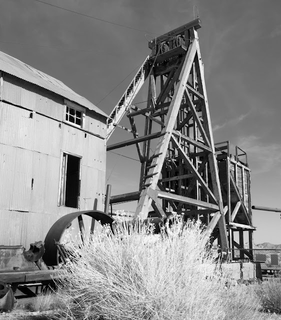
In my darkroom days of dim lights and trays of chemicals the process of photography was only just beginning once the negatives were dry. Hands and pieces of cardboard on coathanger handles were used to lighten selected areas of an image by holding back the projected enlarging light, or darken areas by giving them a bit more exposure through a hole in cardboard or an opening configured by contorting one’s hands. It was even possible to locally control contrast, as well as exposure. Image processing in the digital world allows even more control, and the fun and artistic expression of taking an image far from its original look. Options include turning a color image into a black and white one with all of the filtering options previously available in the film world, and then some. Perhaps it was the memory of my earlier photos of the Tonopah mining structures, or the textures and contrasts of the subjects themselves that called for a black and white representation, but that’s where I found myself going in the processing stage of the Tonopah photos taken as we wandered through the outdoor Tonopah Mining Museum. 


The Silver Top tipple - 1968
We rambled around and within the old structures and buildings until closing time, then gassed up and headed out Hwy 6 for a bit, then north on 376 and finally attempting to skirt the potholes of 82 to the Belmont campground, pleasantly located among pinon pines, junipers, and warm-colored outcrops of deeply-weathered granite. The campground has no water supply, but does include clean pit toilets and is well maintained by the Belmont community. 

As we set up the trailer where it would be our home for the next three nights Eric pointed out deep sidewall cracks in one of its tires. Discovering that the spare had insufficient pressure, we put our heads together for a moment and came up with the thought that, “Someone in town must have an air compressor”. And so we enjoyed a dinner of delicious Indian curry cooked by Eric, confident in solving our problem, but really having no idea of the degree of kindness and warmth of the Belmont community we would unleash in the coming few days.


Inside the hoist operator's station, Silver Top Mine, Tonopah

Door to the Silver Top Mine hoist

The huge timbers for the Desert Queen hoist works were shipped by rail and freight wagon from Truckee, California,
The hoist drum for the Silver Top Mine is about 7 feet in diameter. Chalk marks in the operator's station say that it was last used in 1944. Contrary to the graffiti and decay I feared to find, these and other remnants of mining history were
obviously appreciated and well cared for by local and county groups. Buildings were even more accessible than when
I had wandered around them in the late 1960's with my camera.

Hoist controls for the Silver Top shaft. The wheel seen through the door on the left is an indicator showing the
operator the level of the man cage or cart elevator. Once raised to the surface the carts were rolled across to
the tipple seen below, where the ore was dumped into railcars for shipment to a mill.

The Silver Top tipple looks much as it did in 1968 when I photographed it with my twin lens Ricoh. The difference is that
it is now safely accessible.

Eric peruses the gazetteer planning the next leg during lunch at the museum parking lot in Tonopah. I've put together our "San Juan Tuna" - a recipe learned on a river trip in southeast Utah. Key ingredients include olives, raisins, chopped nuts, small diced apple - as well as tuna and mayo. One of Orowheat's heartier breads and lettuce wraps it up. Eric planned and prepared all of our dinners, based on curry dishes he had enjoyed in India.

Monday, May 22, 2017

Central Nevada Road Trip - Part 2. Mono Lake Camp

Mono Lake looking south down CA 395
(Click on the photo to view larger versions of all of the photos in sequence)
Vast as it is, covering 70 square miles and filled with ¾ of a cubic mile of water, Mono Lake is but a puddle of its former self. From when it was formed about a million years ago, until the end of the last ice age about 10,000 years ago, it was up to 500 feet deeper and twice as large,  extending from what is now California well into western Nevada.

The tufa columns of Mono Lake were created as
underwater springs deposited dissolved minerals.
The ancestral Mono Lake was one of several large Lakes within the Great Basin during that time, known by geologists as Pliocene – Pleistocene time. The Great Basin is an area of internal drainage including most of Nevada and eastern California – rivers within the Great Basin are trapped by topography and never make it to the sea. The Great Basin formed beginning about 4 million years ago as the movement of tectonic plates began to pull that part of the continent apart, tilting some crustal blocks and dropping others as fault-bounded valleys, or grabens. The ongoing expansion and tilting created the Sierra Nevada range and the fault block mountain ranges of Nevada. The down-dropped grabens form the vast, 40-mile-view sagebrush-covered valleys. Passing through that landscape seen from the point of view of our life span, minuscule in comparison to geologic time, all seems stable, the mountains and vast valleys as having existed unchanged forever. In fact, by speeding up time in our imaginations as a stop motion video, we can see the mountains continually rising, while being worn down by erosion nearly as fast as they rise, their sediments carried into the valleys by periodic catastrophic flash floods building huge alluvial fans and filling the basins to depths of many thousands of feet.

The desert quiet enhanced the gentle sounds of birds. Two of them flew into this shot as I was setting up, to perch on the top of a tufa tower.


Tufa towers at sundown,

A nearly full moon rose to add to the feeling of otherworldly ambiance

Chancing eviction we camped in a parking lot near the lake
to encourage us to emerge from cozy beds to catch the morning light.

Our first night's camp on the south shore of Mono Lake

Breakfast with a view before heading east and deeper into the Nevada desert.


Central Nevada Road Trip – a father and son experience in deep Nevada - Part 1. The Beginning


Eric and Tony Mindling, Berlin, Nevada, May 15, 2017
Photo by Eric Mindling
(Click on the photo to view larger versions of all of the photos in sequence)

Pops and the Kid. Today we emerged from Deep Nevada back into the world of cel and internet and people in too much of a hurry to do who knows what. We went to another world beyond the sagebrush curtain, saw vast places, met people who live by another rhythm and shared time together that was pure goodness for the heart and soul. Pictures will follow, and those of you lucky enough to cross our paths in these days can hear stories. There are things truly worth doing in this life, and this was one of them.
Eric Mindling, May 15, 2017

Part 1. The Beginning


The funny feeling in the truck’s steering was back. On the straight, as our long-suffering F150 patiently hauled our 27-foot travel trailer up the long grades leading to Donner Pass, where the I-80 finally drops over the summit of California’s Sierra Nevada, I’d been trying to convince myself that all was well. I was about an hour from our home in the foothills on the gentle west slope of the Sierras, and finally relaxing into this first leg of a much-anticipated road trip with my son Eric into Central Nevada. I’d soon be meeting him in Carson City, from which, according to plan, the next morning we would be heading south down 395 beneath the steep eastern face of the Sierra’s to Lee Vining, spend the night camping in the desert on the shore of million-year-old and mysterious Mono Lake, then east toward Tonopah from which we’d plunge off the pavement into “deep” Nevada.

The trip would be a photographic re-visit to the desert clarity, weathered old mining town buildings, hot springs, and cattle ranches I’d last seen 50 years earlier. Then I was a young geologist, bouncing a stiff 4X4 over two-track roads in search of springs which I would sample, measure their flow rate and temperature, and describe their occurrence. Enthralled by the colors and texture of the desert, my latent interest in photography received a reboot carrying my pleasure in it to my present 77 years.

Amazingly, and to my great pleasure, my son Eric picked up a passion for the craft, taking it far beyond my imaginings, to photograph for many years in southern Mexico, and most recently returning from projects in Cuba and India. So when I’d emailed him a few weeks ago with my idea to revisit the desert places I’d known in my 20’s, ending with, “Wanna come?!”, I’d assumed he’d be soon flying off for another project and I would be doing the trip solo.

But now I was truly on the way to meet him and soon together we’d be off on a father-son adventure of a lifetime. Except that as I eased my truck and travel trailer rig into one of I-80’s smooth freeway bends I could no longer ignore the resistance to turning the steering wheel, as if the power steering had failed. After pulling off onto a fortuitously wide section of shoulder, a straightened out bit of the old Lincoln highway, still bounded by lovely hand-laid stone protective fencing, I found that, indeed, the power steering no longer functioned, along with the alternator, fan, air conditioner, and coolant pump, all of 
which had been driven by the now-deceased serpentine belt whose shreds were now complexly wrapped around the fan’s shaft.

No doubt we will bore our grandchildren with the details of how on the side of the road, despite the failure of CSAA to be any help at all despite the membership dues that I pay expecting the benefits of “roadside assistance”, a replacement belt was obtained, and Eric diverted from his trip from Oregon to his mother’s home in Carson City to lend his strong arm as the third hand necessary to slip the new belt over the final pulley, and I was on the way again in time to arrive in Carson City in time for a glass of wine before a very welcome supper served up by Eric’s mom, Jean.

The Cosmopolitan Hotel, Belmont, Nevada 1968
Sitting around the old round table, we paged through a book of old silver-gelatin prints of the photos I’d taken of the ranches, abandoned mines, and weathered buildings of the central Nevada of 1968 and 1969. Those black and white photos – rusted ore cars tumbled from tracks leading into an abandoned tipple, branding irons casting shadows on a white-washed stone building, a close-up of a weathered door – had hung in our home for a decade and longer. Eric no doubt expected that we would be travelling through a world of tones of gray in the days to come. I feared finding buildings covered with graffiti, surrounded by trash, their history unappreciated. In fact, we would both be filled with the beauty of the colors and textures of the desert, the warmth and unaffected kindness of its people, and their deep appreciation of the land and its history. 

Nye County Courthouse, Belmont, Nevada. 1968

Ore cars and tipple, Silver Top Mine, Tonopah, Nevada. 1968


Branding Irons, Twin Springs (Fellini) Ranch, Nye County, Nevada, 1969

Weathered door, Belmont, Nevada. 1968