February 3, 2012
3.2 Miles
I accessed the trailhead, located where the Ponderosa Way Bridge crosses the North Fork of the American River, by dropping down Ponderosa way from the Foresthill Road between Auburn and Foresthill. You can also zig-zag down Ponderosa way from I-80 near Colfax. Either way you are dealing with switchbacks, dirt roads that are rough in places, and some fine views of the canyon of the North Fork. You would probably make it fine in your Miata, but feel most secure in a high-centered, AWD vehicle.
 |
| The frosty Ponderosa way bridge over the North Fork off the American River |
 |
| The trail to Codfish Falls |
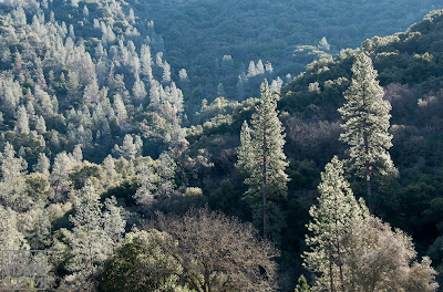
The morning light spilling down the opposite slope of the canyon outlined the tall Grey Pines in delightful backlighting. Until recently these trees had been know commonly as "Digger Pines", a name applied with reference to the Nissenan, or Southern Maidu, by the gold miners of the 1800's, based on their observation that they commonly dug up roots for food and other uses. The miners also left behind piles of cobbles on a bar along the opposite bank, washed clean by hydraulic mining. The resulting sediment carried down the American, and other rivers, into the Central Valley built up there, causing flooding and damaging agricultural land. A temporary solution on the NF was to build the Clementine Dam downstream a few miles, solely for the purpose of trapping the sediment before it could be carried further downstream. Shortly thereafter the release of sediment was outlawed by the nation's first environmental legislation.
 |
| Grey pines backlit by the morning sun |
 |
| Codfish Falls |
Walking into the tributary canyon the rush of the river fades and is replaced by the gurgle of Codfish Creek, and soon the cascading flow of the falls can be seen through the trees. I stumbled around on the rocks a bit taking photographs of the falls and the fern and moss-lined grottoes just downstream. My legs were a bit shaky after spending about an hour crouching here and there behind the camera, so I bypassed the trail heading a bit further to the top off the falls - I'll return there with grandchildren to complete the exploration in the spring.
Not far back down the trail I came upon a dad with three young daughters and a Shi-Tzu heading toward the falls. The scene took me back to our days in Susanville, when the kids were in high school and we often made treks like that.
So I'm going to try to kidnap some grandchildren for another trip to Codfish Falls, this time all the way to the top. But we'll do it no later than April, as this will be a warm trail later in the summer. But then, there are those inviting side trails down to swimming holes carved in the rocks by the river.
Back in the Explorer, and a bit disappointed that I'd missed Science Friday I headed out of the canyon continuing on Ponderosa Way which switchbacks its way in fairly spectacular fashion back to pavement, scattered homes, and finally I-80. Joining the rush of traffic, I still carried some shreds of the relaxation I had felt on the trail and while photographing Codfish Creek, and reflected on how easy it is to access places like that once you let your feet carry you away from roadways.
*At home I checked the weight of a $40 aluminum Sunpak tripod I picked up once for travelling. Turns out it is lighter than a Gitzo Mountaineer carbon fiber with head. $600 saved.
 |
| Codfish Creek. 1.3 sec at f/20, ISO 100 |
 |
| Codfish Creek. 1 sec at f/20, ISO 100 |


Good evening,
ReplyDeleteI love your photos, and would love to connect with you to see if you might be interested in letting us use some of them for our new website www.visitplacer.com. The new site isn't live yet, as we are populating it with data. If you'd be interested in us purchasing some usage, please email me at mora@visitplacer.com.
Gratefully,
Mora